


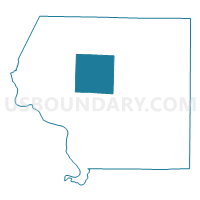
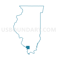
LEVAN Voting District, Jackson County, Illinois
About
Outline

Summary
| Unique Area Identifier | 571243 |
| Name | LEVAN Voting District |
| County | Jackson County |
| State | Illinois |
| Area (square miles) | 36.77 |
| Land Area (square miles) | 33.36 |
| Water Area (square miles) | 3.41 |
| % of Land Area | 90.72 |
| % of Water Area | 9.28 |
| Latitude of the Internal Point | 37.82424480 |
| Longtitude of the Internal Point | -89.43889750 |
Maps

Graphs
Select a template below for downloading or customizing gragh for LEVAN Voting District, Jackson County, Illinois


Neighbors
Neighoring Voting District (by Name) Neighboring Voting District on the Map
- BRADLEY - AVA Voting District, Jackson County, IL
- FOUNTAIN BLUFF Voting District, Jackson County, IL
- KINKAID Voting District, Jackson County, IL
- MURPHYSBORO 8 Voting District, Jackson County, IL
- ORA Voting District, Jackson County, IL
- SAND RIDGE 1 Voting District, Jackson County, IL
- SOMERSET 2 Voting District, Jackson County, IL
- SOMERSET 3 Voting District, Jackson County, IL
- Somerset 4 Voting District, Jackson County, IL
- VERGENNES Voting District, Jackson County, IL
Top 10 Neighboring County Subdivision (by Population) Neighboring County Subdivision on the Map
- Murphysboro township, Jackson County, IL (10,563)
- Somerset township, Jackson County, IL (4,205)
- Bradley township, Jackson County, IL (1,951)
- Levan township, Jackson County, IL (850)
- Sand Ridge township, Jackson County, IL (816)
- Vergennes township, Jackson County, IL (771)
- Ora township, Jackson County, IL (514)
- Kinkaid township, Jackson County, IL (486)
- Fountain Bluff township, Jackson County, IL (208)
Top 10 Neighboring Unified School District (by Population) Neighboring Unified School District on the Map
- Murphysboro Community Unit School District 186, IL (15,612)
- Trico Community Unit School District 176, IL (6,525)
- Elverado Community Unit School District 196, IL (3,108)
Top 10 Neighboring State Legislative District Lower Chamber (by Population) Neighboring State Legislative District Lower Chamber on the Map
Top 10 Neighboring State Legislative District Upper Chamber (by Population) Neighboring State Legislative District Upper Chamber on the Map
Top 10 Neighboring 111th Congressional District (by Population) Neighboring 111th Congressional District on the Map
Top 10 Neighboring Census Tract (by Population) Neighboring Census Tract on the Map
- Census Tract 104, Jackson County, IL (4,627)
- Census Tract 101, Jackson County, IL (3,539)
- Census Tract 103, Jackson County, IL (3,115)